Where should the (northern) SNAP field be? It must be somewhere close to the North Ecliptic Pole (NEP). Some of the criteria for choosing the exact location are:
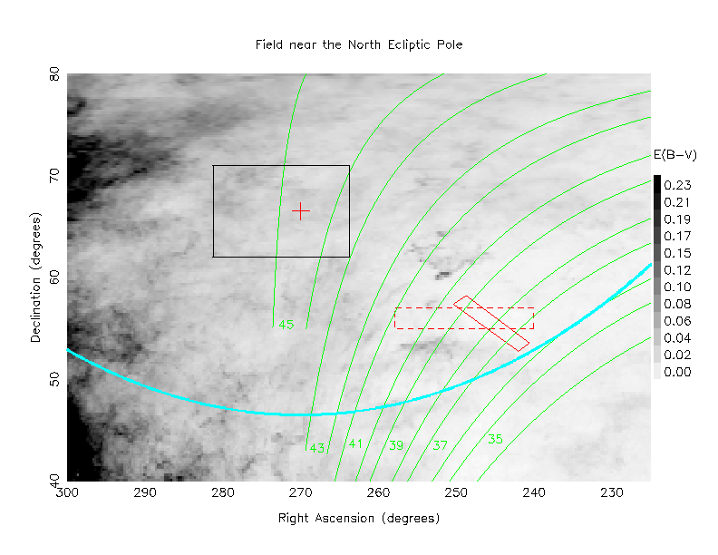
Below is a chart showing the area near the NEP. The grayscale background image is a representation of the foreground extinction, based on the work of Schlegel, Finkbeiner and Davis (1998). A legend on the right side of the chart gives the reddening E(B-V) for each grayscale value. Note that extinction is based on the reddening in roughly the following manner:
      B-band:  extinction = 4   x E(B-V)  in magnitudes
      V-band:  extinction = 3.1 x E(B-V)
      I-band:  extinction = 1.5 x E(B-V)
      K-band:  extinction = 0.6 x E(B-V)
A red cross marks the location of the NEP. The red rectangle drawn with dashed lines is a 10-degree by 2-degree box centered on (RA = 16h 38m, Dec = +56), the position suggested by Greg Aldering in his presentation at the 2002 Collaboration meeting. The solid red rectangle is a new suggestion for the northern SNAP field, centered at (RA = 16:21, Dec = +55:35), again provided by Greg Aldering. This is galactic latitude b = +43, galactic longitude +84 degrees. The green lines show the boundaries of SDSS scanning "stripes;" only odd-numbered stripes are shown for clarity. The white rectangle shows the area of the ROSAT North Ecliptic Pole Survey The light blue line is 20 degrees from the NEP, marking the limits of the Sun avoidance mechanism of the spacecraft.
The reddening values in a 3-by-3-degree area centered on the NEP average E(B-V) = 0.043 with stdev 0.004. In the center of the new Aldering box, the average is E(B-V) = 0.008 with stdev 0.001.
As you can see, the NEP lines in SDSS stripe 45, whereas the new Aldering area spans stripes 37-40.
Now, which SDSS scans have been completed so far? The areas already covered are shown in blue hashmarks in another copy of the figure.
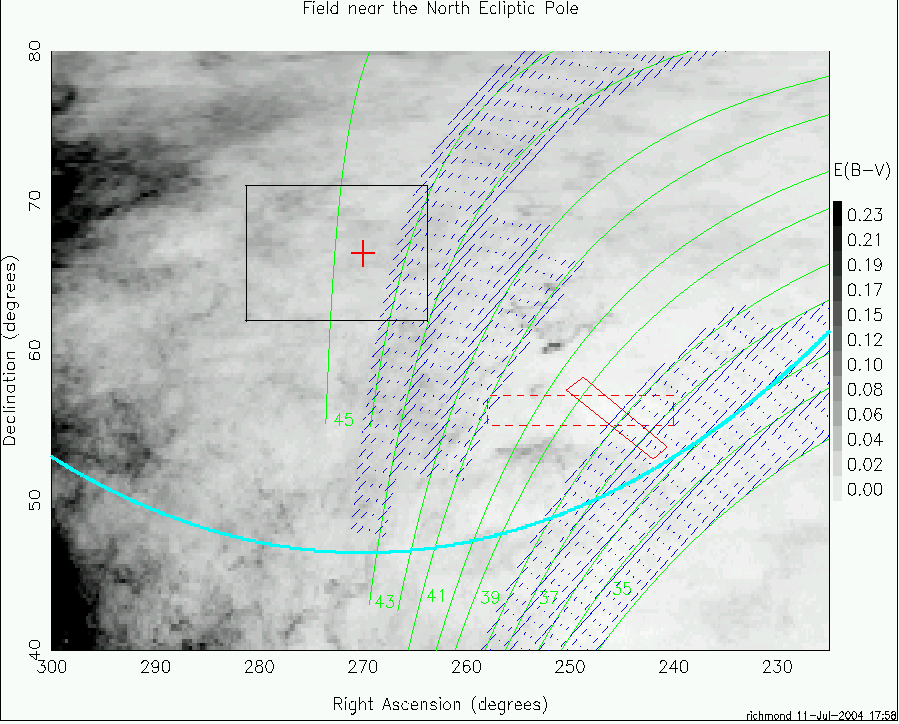
The SDSS has not scanned the NEP; it has scanned a fraction -- perhaps 50 percent -- of the new Aldering box.
Greg Aldering writes (5/2/2003)
Since you list other surveys, you may wish to note that one of the Elias deep fields which will be done by SIRTF is in the region I have selected. I think this will help SNAP in making better corrections for Galactic extinction since the dust will be better charactized and the dust-map resolution should be much better than it is for the SFD maps.
Note that the location of the SEP was indicated incorrectly on early versions of this document. It was fixed on July 11, 2004.
Below is a graph showing interstellar extinction in the direction of the South Ecliptic Pole (SEP): RA = 90 degrees, Dec = -66.5 degrees. The field of view is slightly larger than in the figures of the NEP, and the view is distorted because it uses RA and Dec to show a region close to the southern equatorial pole. The light blue "triangle" is really a circle 20 degrees in radius around the SEP. Note that there is no extinction data shown in the region of the Large Magellanic Cloud (LMC), which SNAP must avoid in any case.
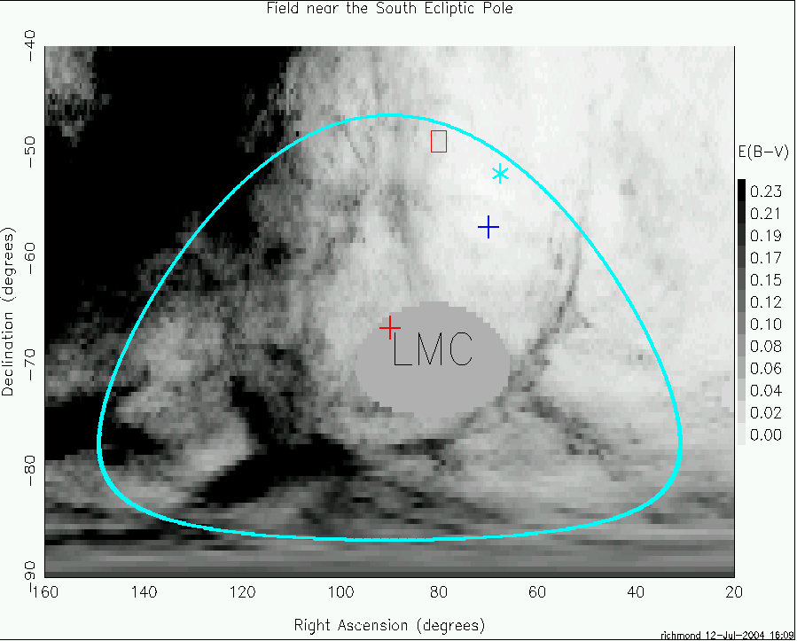
The reddening at the SEP itself (marked with a red cross) is not given in the Schlegel et al. paper, because the LMC interferes with the measurement. Mike Lampton suggests using a region near the clear patch around RA = 70 and Dec = -59, marked with a blue cross. The extinction in this part of the sky can be as small as E(B-V) = 0.010. Back in 1999, Greg Aldering suggested a region near RA = 67.5 and Dec = -52, shown as a light blue asterisk; its reddening is about the same, E(B-V) = 0.010.
The Deep Lens Survey consists of five fields, each 2x2 degrees. One falls within the limits of SNAP's view, at RA = 80 degrees and Dec = -49 degrees. It is shown as a red box in the graph above. Doug Tucker writes:
Allyn Smith points out that Tony Tyson's Deep Lens Survey has deep, multi-epoch, BVRz photometry in a region of sky centered at RA=05:20:00, DEC=-49:00:00 (ecliptic coords=69deg,-72deg), which is only 11.6deg away from Mike Lampton's recommended pointing. Allyn has also obtained several epochs of ugriz photometry in this field as part of the Southern u'g'r'i'z' standards project (http://home.fnal.gov/~dtucker/Southern_ugriz/index.html).This location, however, appears to have a marginally higher extinction -- E(B-V) = 0.02 rather than E(B-V)=0.01 -- according to the Deep Lens Survey webpage (http://dls.bell-labs.com/).
This area is so close to the Milky Way that the 2dF survey did not cover any of it. The "southern" portions of the SDSS does not go through this area, other. The HST Southern Deep Field and Chandra Southern Deep Fields fall outside the area.