Now, to take in the full meaning of the condition of the cap at this time and of the changes that ensued, we must begin by determining the Martian time of year. This is done by fixing the dates at which the Martian pole reached its maximum tilt toward or from the Sun, and the dates at which it was not tilted either to or from, but sideways to, the Sun; the former gives us the Martian solstices, and the latter the Martian equinoxes. It thus appears that on April 7, 1894, occurred the vernal equinox of the Martian southern hemisphere, on August 31, its summer solstice, and on February 7, 1895, its autumnal equinox. From these dates it is easy to transform the one calendar into the other. On the 3d of June, 1894, therefore, it was about May 1 on the southern hemisphere of Mars.
On May 1, then, Martian time, the cap was already in rapid process of melting;
and the speed with which it proceeded to dwindle showed that hundreds of square
miles of it were disappearing daily. As it melted, a dark band appeared
surrounding it on all sides. Except, as I have since learned, at Arequipa, this
band has
never, I believe, been distinctively noted or commented on before,
which is singular, considering how conspicuous it was at Flagstaff. It is
specially remarkable that it should never have been remarked upon elsewhere, in
that a similar one girdling the north polar cap was seen by Beer and Madler as
far back as 1830. For it is, as we shall shortly see, a most significant
phenomenon. In the first place, it was the darkest marking upon the disk, and
was of a blue color. It was of different widths at different longitudes, and
was especially pronounced in tint where it was widest, notably in two spots
where it expanded into great bays, one in longitude 270 degrees and one in longitude
330 degrees. The former of these was very striking for its color, a deep blue, like
some other-world grotto of Capri. The band was bounded on the north, that is,
on the side toward the equator, by the bluish-green areas of the disk. It was
contrasted with those both in tone and tint. It was both darker and more blue.
The band not only varied in width at different longitudes, but its width
corresponded to the amount of the blue-green areas of the disk visible at these
longitudes below it. It was widest where these were greatest in extent, and
narrowest where they were least. If we consult the map of Mars we shall see
that below the bay in longitude 330 degrees lies the great dark
area, the Syrtis Major,
and, below the one in longitude 270 degrees, the Syrtis Minor. This correlation was
highly suggestive in itself. As if, however, to remove all question as to
possible coincidence having a hand in the matter, the agreement in position was
emphasized by visible connection. Two long dark streaks appeared joining
respectively each bay to its corresponding Syrtis.
But the most significant fact about the band was that it kept pace with the
polar cap's retreat toward the pole. As the white cap shrank it followed pari
passu so as always to border the edge of the snow. It thus showed itself not
to be a permanent marking of the planet's surface, since it changed its place,
but a temporary one, dependent directly upon the waning of the cap itself. In
short, it was an associated detail, and itself instantly suggested its
character, namely, that it was water at the edge of the cap due to the melting
of the polar snow.
Not only did the band conform with the cap in position; it did so in size. As
the snows dwindled, the blue band about them shrank in width to correspond. By
August it was a barely discernible thread drawn round the tiny white patch
which was all that remained of the enormous snow-fields of some months before.
Finally, on October 13, when the snow entirely disappeared, as we shall
presently see, the spot
where it and its girdle, long since grown too small for
detection, had been became one yellow stretch.
That the blue was water at the edge of the melting snow seems unquestionable.
That it was the color of water; that it so persistently bordered the melting
snow; and that it subsequently vanished, are three facts mutually confirmatory
to this deduction. But a fourth bit of proof, due to the ingenuity of Professor
W. H. Pickering, adds its weight to the other three. For he made the
polariscope tell the same tale. On scrutinizing the great bay through an Arago
polariscope, he found the light coming from the bay to be polarized. Now, to
polarize the light it reflects is a property, as we know, of a smooth surface
such as that of water is.
Before going further we will take up here at the outset the question of the
constitution of these polar caps, which in their general behavior so strikingly
suggest our own ice-caps as they would appear could they be seen from a
distance of forty millions of miles. That they so instantly suggest snow has
suggested, to that class of mind which likes to make of molehills of question
mountains of doubt, the possibility that instead of ice we have here snow-caps
of solid carbonic acid gas (carbon dioxide). The occasion of the suggestion is
the fact that carbonic dioxide under certain conditions becomes
a colorless
liquid, and then a solid of a floccular, snow-like character. It assumes, in
short, under proper conditions of pressure and cold, the various appearances
presented by water under higher temperatures, although it does so with very
different degrees of ease. Superficially, therefore, the idea seems plausible.
Let us see if it still seems so when critically examined.
Faraday made experiments on the relation of the congealing point of carbonic
acid gas to the pressure, and found that at 0 degrees C. it took a pressure of 36
atmospheres, that is, 540 pounds to the square inch, to solidify the gas, and
that at -99 degrees C., the lowest temperature with which he experimented, it took
1.14 atmospheres. At this point the curve representing the relation was
becoming apparently asymptotic, that is, a slight decrease in pressure involved
a great falling off of temperature. Under a pressure of one atmosphere,
therefore, the temperature would be about -170 degrees F., that is, on the surface of
the Earth this would be the congealing point of the gas.
He found further that the curve for the liquefaction point lay very close to
that for the congealing point, and approached yet closer as the pressure
decreased. In other words, the gas passed almost immediately from the gaseous
to the solid state.
In the light of these facts let us consider the
condition of Mars. Three points
arise which we will take in the inverse order of their importance. First: the
appearance of the planet shows conclusively that, if the polar caps be composed
of solid carbonic acid gas, then either there is no water at all on Mars in any
form whatsoever, or what there is is ice so overlaid with detritus as to be
invisible. For if the two substances were there together, and the cold at the
surface of the planet of so extreme a character as to congeal the carbon
dioxide, the water must a fortiori be frozen, and would continue so long
after the temperature rose above the melting point of the former substance. We
should therefore still have snow-fields of snow after the melting of those
formed of carbonic acid gas, either visible as white patches or so covered up
with dirt as to pass for land. Now there are no such additional white patches
to be seen, nor, so far as we can judge, does any part of the planet behave as
if it were glacier-bound.
Second: carbonic dioxide passes, as we saw, almost simultaneously into the
liquid and solid states, especially under slight pressure. Now, the pressure is
certainly very slight on the surface of Mars; not probably more than, and
probably less than, one seventh of an atmosphere. In consequence, on a rise of
temperature the frozen carbonic acid gas would there pass practically straight
from the solid into the gaseous
state. Now, from the existence of the
surrounding polar sea, we remark that in the substance composing the polar caps
of Mars this does not occur. A considerable portion of it is always in the
transition state of a liquid. Carbonic dioxide would not thus tarry : water
would.
Third: from the curve of metamorphosis, it is evident that the temperature
necessary to freeze the gas under the pressure of one seventh of an atmosphere
must lie between -100 degrees C. and -200 degrees C., if not lower. -200 degrees C. is, so far as we
can judge, about the temperature of inter-planetary space, or what would be the
temperature of the night side of Mars were the planet destitute of atmosphere.
But there is an atmosphere on Mars, and, even if there were not, on melting the
carbonic dioxide would itself make an atmosphere. This would instantly raise
the temperature, and under any rise in temperature the congealing of the gas at
once becomes an impossibility. The gas itself thus suggests its own refutation.
There is no such apparent objection to water. With an atmosphere properly
constituted (and there is nothing to show that the Martian atmosphere is not so
constituted), the temperature might easily rise high enough to melt ice. We may
therefore conclude water to be the most probable solution of the question.
With such more or less solid ground to
stand on, we may now go on to describe
the behavior of the cap as constituted of snow. Whether we call it snow-cap or
ice-cap is immaterial, as, although it would probably be deposited as
hoar-frost rather than as snow in the first instance, owing to the thinness of
the Martian air, the latter end of either form of the substance would be much
the same,--glacier-ice.
It will, be interesting to examine more in detail the annual history of the
ice-cap, especially as this history was unrolled before us last year more
minutely than has been the case for the last fifteen years, and than will be
the case for fifteen years to come. This was due not only to the relative
proximity of the planet during the last opposition, but to the further fact
that its south pole was tilted toward us at maximum angle. The vicissitudes
which the polar cap underwent stood, in consequence, remarkably well displayed.
To such advantage were they seen that it has been possible to construct a map
of the Martian south circumpolar regions to a degree of detail such as has
never been possible before, and which I have accordingly done. It will be seen
from it (on the opposite page) how much farther advanced is our knowledge of
the Martian south pole, and the regions about it, than is our knowledge of
either of our own.
It is also pleasing to
remember that during this our polar expedition we were
not frost-bitten for life, nor did we have to be rescued by a search party. We
lived not unlike civilized beings during it all, and we actually brought back
some of the information we went out to acquire.
On examining the chart in which the successive appearances of the southern
ice-cap are depicted at different times, from June 3 to October 13, or, in
terms of the Martian time of year, from May 1 to July 15, the first point to
strike one is that the cap was during its whole existence eccentrically placed
with regard to the geographical pole of the planet. In other words, the pole of
rotation and the pole of cold did not coincide. The latter lay on the average
some six degrees distant from the former. This shows that the isotherms in the
southern hemisphere of Mars do not coincide with the parallels of latitude.
The manner of the cap's melting further shows that differences of level exist
in it. For, in addition to melting round its edge, the cap proceeded to melt
asymmetrically. On the first night that Professor W. H. Pickering observed it,
on May 22, with the six-inch telescope, he suspected a rift crossing the cap
from longitude 330 degrees to longitude 170 degrees. This rift grew more and more evident,
until, in the early part of June, it was unmistakable. It grew in visibility
chiefly from actual growth in size. On June 6
it was estimated, on a scale of
ruled lines made for the purpose, to be about 100 miles wide. On June 15 it was
similarly found to measure 220 miles.
Meanwhile an interesting phenomenon occurred in the cap on June 7. On that
morning, at about a quarter of six (or, more precisely, on June 8, 1h. 17m., G.
M. T.), as I was watching the planet, I saw suddenly two points like stars
flash out in the midst of the polar cap. Dazzlingly bright upon the duller
white background of the snow, these stars shone for a few moments and then
slowly disappeared. The seeing at the time was very good. It is at once evident
what the other-world apparitions were,--not the fabled signal-lights of
Martian folk, but the glint of ice-slopes flashing for a moment earthward as
the rotation of the planet turned the slope to the proper angle; just as, in
sailing by some glass-windowed house near set of sun, you shall for a moment or
two catch a dazzling glint of glory from its panes, which then vanishes as it
came. But though no intelligence lay behind the action of these lights, they
were none the less startling for being Nature's own flash-lights across one
hundred millions of miles of space. It had taken them nine minutes to make the
journey; nine minutes before they reached Earth they had ceased to be on Mars,
and, after their travel of
one hundred millions of miles, found to note them
but one watcher, alone on a hill-top with the dawn.
Calculation showed the position of the star-points to be in longitude 280 degrees and
290 degrees and in latitude 76 degrees south. At this place on the planet, then, there was a
range of slopes sufficiently tilted to reflect the Sun from their ice-clad
sides. On comparing its position with Green's map of his observations upon the
cap at Madeira in 1877, it appeared that this was the identical position of the
spot where he had seen star-points then, and where Mitchell had seen them in
1846, to whom they had suggested the same conclusion. Green christened them the
"Mitchell Mountains." At the times both these observers saw them, they were
detached from the rest of the cap. At the time of this observation in June,
they were still in the midst of the cap. We shall see that they eventually
became islands, just as Green saw them, and that the observation in June marked
an earlier stage in their history.
On June 10 Mr. Douglass detected a second rift in the cap backing the range of
slopes. And on June 13 I noticed that behind the bright points the snow fell
off shaded to this rift. Meanwhile a third rift had been made out by him,
running from longitude 170 degrees to longitude 90 degrees,--very nearly, therefore, at
right
angles to the first rift and debouching into it. Bright points continued
to be seen at various points to the westward round the cap. They are marked by
crosses on the chart. Throughout these days, the cap was wont to appear shaded
upon the terminator side, as one might expect of a snow or ice slope. During
June, also, the contour of the cap was apparently elliptical. But on June 25
Professor W. H. Pickering noted, for the first time, that it no longer looked
so. The melting had resulted in making its asymmetry perceptible.
On July 1 our Martian polar expedition disclosed what used to be the supreme
quest of earthly expeditions,--that dream of arctic explorers, an open polar
sea. On that day Professor Pickering perceived, in the midst of the cap, in
longitude 260 degrees and latitude 80 degrees, a sheet of water about 250 miles long by 150
broad. It was in fact the spreading of the first rift about midway across the
cap, and lay not far from the geographical pole of the planet, though not, it
is to be noticed, near the pole of cold for it lay on the further side of the
geographical pole from it. There is a touch of the irony of fate in this
detection of an open polar sea on Mars before explorers have succeeded in doing
so on the Earth.
In addition to these rifts and other irregularities of melting, small detached
bits of the
cap showed from time to time, one being seen by Professor Pickering
on July 9 in longitude 284 degrees, and another by him on July 23 in about longitude
160 degrees.
Meanwhile the cap had been steadily decreasing in size, its progressive
diminutions being shown on the map in the successive contour lines. The polar
sea faithfully followed it in its shrinkage, even the bays keeping their
longitudes unchanged. But, whereas early in June the bay at longitude 270 degrees had
been blue, it now appeared brown; of that mud-color land does from which the
water has recently been drained off.
After various vicissitudes, too numerous to mention in detail, on August 6 a
separate patch of snow showed very conspicuous, to the left of the main body.
The smaller detachment lay in longitude 290 degrees, and in latitude 75-78 degrees. Now, on
turning to the record of the star-points that had appeared two months before,
it will be seen that this was their position. Here, then, was proof of the
identity of the star-points seen in June with the islands recorded by Mitchell
and Green. The detached patch was in fact the range of slopes left in isolated
insularity after all about it had melted away. From this we have an interesting
bit of corroborative testimony that it stood on higher ground.
On August 11 the detached patch was yet
farther separated from the main body of
the cap, the smaller patch being many degrees distant to the north of either
the geographical pole or the pole of cold, with water and even dry land to the
south of it. It will be remembered, for the points of the compass, that this is
the southern hemisphere of which we are speaking, and that, for climatic
purposes, north and south here stand interchanged. On August 13 the detached
patch is recorded for the last time, or, in other words, about this time it
melted away. The larger one remained, contracting in size, however, as time
went on. So it continued through August, September, and well into October.
On October 12, at 10h. 40m., I made the following entry about it: "Polar cap
has been very faint for some time; barely visible." At 13h. 26m., or, in other
words, at about half past one that night, Mr. Douglass measured its position
and estimated its size, as was his wont every few days. He found it to be six
degrees distant from the planet's pole, in longitude 54 degrees The patch was very
small, covering about one hundred and fifty miles square. On looking at the
planet on October 13, at 8h. 15m., to his surprise he found the cap gone. Not a
trace of it could be seen; nor could either he or I detect it during the rest
of that night although such was the longitude of the central
meridian
throughout it as to bring the cap on the nearer side of the pole, and
therefore show it to best advantage. What had certainly been there on the 12th
was not there on the 13th. The ice-cap had disappeared.
No such occurrence has ever been chronicled before. It is the first time since
man began to observe the planet that the ice-cap has completely disappeared.
Hitherto it has been seen to diminish to a minimum of from 7 to 4 degrees, and then
begin to increase again. This last autumn, for the first time, it vanished
entirely. The date of this occurrence was, in Martian chronology, about July
20. Evidently, for some reason unknown to us, it was a phenomenally hot season
in the southern hemisphere of the planet.
Practically it never reappeared again during the season. That it did return
occasionally, as a very small speck, was from time to time suspected, and
doubtless did take place. Certainly it left for some time behind it a glimmer
where it had been, due presumably to the moisture from its melting, still
tarrying on the ground or lingering in the air. Otherwise, to all intents and
purposes, where the polar ice-cap and polar sea had been was now one ochre
stretch of desert.
Having thus followed to its vanishing point the polar cap, we will now return
to it in the
heyday of its youth, in June, 1894, when it was girdled by its
broad blue belt. We have seen that we have reason to believe this to be in all
probability a polar sea, a real body of water. There is, therefore, water on
the surface of Mars. We also mark that this body of water is ephemeral. It
exists while the ice-cap is melting, and then it somehow vanishes. What becomes
of it, and whether there be other bodies of water on the planet, either
permanent or temporary, we will now go on to inquire.
Areography is a true geography, as real as our own. Quite unlike the markings
upon Jupiter or Saturn, where all we see is cloud, in the markings on Mars we
gaze upon the actual surface features of the Martian globe. That we do so we
know from the permanency of the spots and patches thus revealed to us. They
change in appearance, indeed, according to times and seasons, but they alter as
true surface features would, not like cloud-belts that gather to-day and vanish
forever to-morrow. That the markings are essentially permanent has been known
ever since Cassini in 1666 definitely discovered, what Huyghens had thought to
detect in 1659, the rotation of the planet, by means of their periodic
presentations.
The twelve views we shall here scan are of the nature of a map, made in
November, 1894. They represent the ensemble of the drawings from this
observatory, for about that date. The details from these drawings were plotted
upon a globe, which was then tilted toward the observer at the angle at which
the Martian south pole itself was tilted toward--the Earth during November,
and photographed at intervals of 30 degrees. The negatives were then made to
conform as near as might be to the actual look of the planet. To photograph minute
planetary markings directly is, for reasons too long to state here, impossible.
The views give between them the whole surface of the planet shown us at what
corresponds to our first of August. Thus, neither the polar cap nor the polar
sea appear in the pictures, for both had then disappeared. Nor do the southern
parts of the so called straits show, for a similar reason. But from a knowledge
of the features here presented the reader will find interpolation of any others
referred to easy.
Previous to the present chart, the most detailed map of the planet was
Schiaparelli's, made in 1888. On comparison with his, it will be seen that the
present one substantially confirms all his detail, and adds to it about as much
more. I have adopted his nomenclature, and in the naming of the newly found
features have selected names conformable to his scheme, which commends itself
both on practical and on poetic grounds.
We will begin our journey at the origin of Martian longitudes and travel west,
taking the points of the compass as they would appear were we standing upon the
planet. As all astronomical pictures are, for optical reasons, upside down,
south lies at the top of the pictures, west to the right, north at the bottom,
and east to the left. Mars rotates as the Earth does, from west to east, so
that day as it advances across the face of the planet follows the order here
shown in Plates III. to XIV., the order in which we shall observe them. Places
on the right of the picture are in the morning of their Martian day; places on
the left, in its afternoon. To facilitate reference by longitude and latitude,
the globe has been belted by meridians and parallels each 10 degrees apart, and the
meridians have been numbered along the equator. This premised, we will suppose
ourselves to be standing on the equator at its intersection with the 0 degree
meridian.
It will be noticed that the 0 degree meridian passes through the tip of a triangular
peninsula that juts out into a dark area curiously forked, half way across the
picture and about two thirds way down it. The tip of this triangle is the
received Greenwich of Martian longitudes, and has been named by Schiaparelli
the Fastigium Aryn, such having been the name of a mythologic spot supposed by
the ancients to lie midway between the east and west, the north and south, the
zenith and nadir. It thus makes a fitting name for the starting-point of
Martian longitudes and the beginning of time. The dark forked area, called by
Proctor "Dawes' Forked Bay," is now commonly called the Sabaeus Sinus. At the
times these marine
names were bestowed, it was supposed that the dark markings
really represented water. We have now reason to believe that such is not the
case. But it is better to keep the old names, although I shall employ them in a
Pickwickian sense, much as we still speak of the Seas of the Moon, the Mare
Tranquillitatis, or the Mare Serenitatis, of which only the adjectives have in
them anything of truth.
To the west of the Sabaeus Sinus lies another dark, wedge-shaped area, longer
than it but single instead of double. This is the Margaritifer Sinus, or the
Pearl-bearing Gulf, so named before it was known that that name possessed any
significance. But a prescience must have presided over its christening. For we
now know that there is indeed a pearl at the bottom of it,--the round spot
shown in the picture.
Two lines will be noticed prolonging the twin forks of the Sabaeus Sinus. If we
let our look follow down them, we shall mark others and then yet others, and so
we might proceed from line to line all over the bright areas of the planet.
These lines are the famous canals of Mars. With regard to their surprising
symmetry, it is only necessary to say that the better they are seen the more
symmetrical they look. Of the two first mentioned, the right-hand one is the
Gihon, the left-hand one the Hiddekel,
and the spot at the limit of the latter is the Lacus Ismenius. From the pearl
at the bottom of the Margaritifer Sinus, the Oxia Palus, the Oxus runs nearly
north to the Pallas Lacus, while another canal, the Indus, makes off northwest.
Nearly in the centre of the disk are seen two of those strange comet-tail
peninsulas that constitute so peculiar a feature of Martian geography. The
lower is Deucalionis Regio; the upper, Pyrrhae Regio. Across them show two
streaks, which, followed up, will be found to join other streaks traversing the
dark regions. These introduce us to Mr. Douglass' discovery of a whole system
of canals in the dark regions, paralleling the system in the bright areas,--
being similarly straight and similarly intersecting one another, with spots at
the intersections, making what Mr. Douglass aptly terms a checkerboard effect,
as we shall see more strikingly when we get round to the other side of the
planet.
But a second feature of this region is no less noteworthy. Surrounding the
Solis Lacus is a perfect cordon of canals and spots, the chief of which are the
Tithonius Lacus, nearly due north, and the Lacus Phoenicis, or Phoenix Lake,
northwest. The spots are strung like beads upon the loop of the Agathodaemon
and the Daemon. From the northeast end of this string of spots runs the
Chrysorrhoas to the Lacus Lunae on the fifty-eighth meridian. Below it is the
Labeatis Lacus, from which the Gigas starts west, to be lost in the limb-light.
Between the dark regions and the Beak of the Sirens is the peninsula
Phaetontis, crossing which some way up is a short canal known as Herculis
Columnae. Due north of the Lacus Phoenicis is the spot Ceraunius, joined to the
Lacus Phoenicis by the Iris, and to the Tithonius Lacus by the Fortunae. It is
also crossed by the Gigas, the very long canal in the right hand lower part of
the disk, of which we saw the beginning in the last plate, and shall not see
the end till we reach the next one.
Westward of the Lacus Phoenicis there begins to show a congeries of spots and
connecting canals, which come out still more strikingly in Plate VII.
The Sea of the
Sirens is now nearly central. To the west, dividing it from the Mare Cimmerium,
which is just coming into view, is the peninsula Atlantis, curiously uniting
the continents to the islands to the south. Belting the disk from east to west
is the Eumenides-Orcus strung with spots.
Parallel to the Eumenides-Orcus, and skirting the north shore of the Sea of the
Sirens, is the Erynnis. Half way between this and the Eumenides is another
parallel canal, the Parcae. Curving round the bottom of the disk is a chain of
canals, the Pyriphlegethon, Acheron, and Erebus, the last of which runs to the
Trivium Charontis. At the junctions of these various canals may be seen any
number of spots.
Returning to the Mare Cimmerium, we observe in the middle of it a long, lighter
streak, Cimmeria, scarcely perceptible at this last opposition, and, barring
its western end, the second in the procession of similarly inclined peninsulas
that follow one another westward upon this side of the planet, the peninsula
Hesperia, a place with a history, as will appear later on.
To the west of Hesperia and parallel to it is a third comet-tail peninsula,
Lemuria, connecting
Ausonia at the south with Libya to the north, Libya being
upon the equator.
Parallel in a general way to the Nepenthes, and about as much below it as it is
below the coast-line, lies the Astapus, which joins the bottom of the Syrtis
Major to the ends of the Amenthes, Lethes, and Achelous.
Between the Euphrates and the Sabaeus Sinus are several canals and spots that
show the minute manner in which the Martian surface is cut up. But so much only
hints at the state of things existent there. From the markings, not well enough
seen to admit of mapping, it is apparent that the system of lines and spots is
very complete all over the planet.
This brings us back again to the Sabaeus Sinus and the Fastigium Aryn, from
which we set out, after a journey which it takes the rotation of the planet
twenty-four hours thirty-seven minutes and about twenty-three seconds to
accomplish.
With the so-called seas, however, the case is different. Several important
facts conspire to throw grave doubt, and worse, upon their aquatic character.
To begin with, they are of every grade of tint,--a very curious feature for
seas to exhibit, unless they were everywhere but a few feet deep; which again
is a most singular characteristic for seas that cover hundreds of thousands of
square miles in extent,--seas, that is, as big as the Bay of Bengal. The
Martian surface would have to be amazingly flat for this to be possible. We
know it to be relatively flat, but to be as flat as all this would seem to pass
the bounds of credible simplicity. Here also Professor W. H. Pickering's
polariscope investigations come in with
effect, for he found the light from the
supposed seas to show no trace of polarization. Hence these were probably not
water.
In parenthesis we may here take notice of the absence of a certain phenomenon
whose presence, apparently, should follow upon water surfaces such as the
so-called seas would offer us, Although its absence is not perhaps definitive
as to their marine character, it is certainly curious, and worth noting. If a
planet were covered by a sheet of water, that water surface would, mirror-like,
reflect the sun in one more or less definite spot. Looked at from a distance,
this spot would, were it bright enough, be seen as a high light on the dark
background of the ocean about it. It would seem to be a fixed star at a certain
point on the disk, the surface features rotating under it. The necessary
position is easily calculated, and this shows that parts of the so-called seas,
especially at oppositions like the last one, pass under the point. There
remains merely the question of sufficient brilliancy in the spot for
visibility; but as in the case of Mars its brilliancy should be equal to that
of a star of the first magnitude, it would seem brilliant enough to be seen. No
such starlike effect in such position has ever been noticed coming from the
blue-green regions. From this bit of negative evidence, to be taken for what it
is worth, we return again to what there is of a positive sort.
Not only do different parts of the so-called seas contrast in tint with one
another, but the same part of the same sea varies in tint at different times.
Schiaparelli noticed that, at successive oppositions, the same sea showed
different degrees of darkness, and he suggested that the change in tone was
dependent in some way upon the Martian seasons.
Observations at Flagstaff have demonstrated this to be the case, for it has
been possible to see the tints occur consecutively. In consequence, we know not
only that changes take place on the surface of Mars other than in the polar
cap, and very conspicuous ones too, but that these are due to the changing
seasons of the planet's year. We will now see what they look like.
To the transubstantiation of changes of the sort it is a prime essential that
the drawings from whose comparison the contrast appears should all have been
made by the same person, at the same telescope, under as nearly as possible the
same atmospheric conditions, since otherwise the personal equation of the
observer, the impersonal inequalities of instruments, and the
special atmosphere of the station plays so large
a part in the
result as to mask that other factor in the case, any change in the planet
itself. How easily this masking is accomplished appears from drawings made by
different
observers of the same Martian features at substantially the same
moment. Several interesting specimens of such personal peculiarities may be
seen by the curious in Flammarion's admirable thesaurus, "La Planete Mars." In
some of these likenesses of the planet it is pretty certain that Mars would
never recognize himself.
To have drawings simply swear at one another across a page is, in the interests
of deduction, objectionable. For their testimony to be worth having, they must
agree to differ. If, therefore, Mars is to be many, his draughtsman must be
one. So much, at least, is fulfilled by the drawings in which the changes now
to be described are recorded; for they were all made by me, at the same
instrument, under the same general atmospheric conditions. As the same
personality enters all of them, it stands, as between them, eliminated from
all, to increased certainty of deduction. Since, furthermore, the drawings were
all made in the months preceding and following one opposition, change due to
secular variation is reduced to a minimum. As a matter of fact, the changes are
such as to betray their own seasonal character. They constitute a kinematical
as opposed to a statical study of the planet's surface.
The changes are much more evident than might be supposed. Indeed, they are
quite unmistakable. As for their importance, it need
only be said that
deduction from them furnishes, in the first place, inference that Mars is a
living world, subject to an annual cycle of surface growth, activity, and
decay; and shows, in the second place, that this Martian yearly round of life
must differ in certain interesting particulars from that which forms our
terrestrial experience. The phenomena evidently make part of a definite chain
of changes of annual development. So consecutive, and, in their broad
characteristics, apparently so regular, are these changes, that I have been
able to find corroboration of what appears to be their general scheme in
drawings made at a previous opposition. In consequence, I believe it will be
possible in future to foretell, with something approaching the certainty of our
esteemed weather bureau's prognostications, not indeed what the weather will be
on Mars,--for, as we have seen, it is more than doubtful whether Mars has what
we call weather to prognosticate,--but the aspect of any part of the planet at
any given time.
The changes in appearance now to be chronicled refer, not to the melting of the
polar snows, except as such melting forms the necessary preliminary to what
follows, but to the subsequent changes in look of the surface itself. To their
exposition, however , the polar phenomena become inseparable adjuncts, since
they are inevitable ancillaries to the result.
With the familiar melting of the
snow-cap begins the yearly round of the planet's life. With the melting of our
own arctic or antarctic cap might similarly be said to begin the earth's annual
activity. But here at the very outset there appears to be one important
difference between the two planets. On the earth the relation of the melting of
the polar snows to the awakening of surface activity is a case of post hoc
simply; on Mars it seems to be a case of propter hoc as well. For, unlike the
earth, which has water to spare, and to which, therefore, the unlocking of its
polar snows is a matter of no direct economic value, Mars is apparently in
straits for the article, and has to draw on its polar reservoir for its annual
supply. Upon the melting of its polar cap, and the transference of the water
thus annually set free to go its rounds, seem to depend all the seasonal
phenomena on the surface of the planet.
The observations upon which this deduction is based extend over a period of
nearly six months, from the last day of May to the 22d of November. They cover
the regions from the south pole to about latitude forty north. That changes
analogous to those recorded, differing, however, in details, occur six Martian
months later in the planet's northern hemisphere, is proved by what
Schiaparelli has seen; for though the general system is, curiously, one for
the whole planet, the particular character of different parts of the surface alters
the action there to some extent.
For an appreciation of the meaning of the changes, it is to be borne in mind
throughout that the vernal equinox of Mars' southern hemisphere occurred on
April 7, 1894; the summer solstice of the same hemisphere on August 31; and its
autumnal equinox on February 7, 1895.
On the 31st of May, therefore, it was toward the end of April on Mars. The
south polar cap was, as we have seen, very large, and the polar sea in
proportion. That the polar sea was the darkest and the bluest marking on the
disk implies that it was, at least, the deepest body of water on the planet,
whether the so-called seas were seas or not. But from the fact that it was
quite wide,--350 miles,--and that it all eventually vanished, it can hardly
have been very deep. Its relative appearance, therefore , casts a first doubt
upon the fact that the others were seas at all. This polar sea plays deux ex
machina to all that follows.
So soon as the melting of the snow was well under way, long straits, of deeper
tint than their surroundings, made their appearance in the midst of the dark
areas. I did not see them come, but as I afterward saw them go it is evident
that they must have come. They were
already there on the last day of May. The
most conspicuous of them lay between Noachis and Hellas, in the Mare Australe.
It began in the great polar bay, and thence traversed the Mare Erythraemum to
the Hourglass Sea (Syrtis Major). The next most conspicuous one started in the
other bay, and came down between Hellas and Ausonia. Although these straits
were distinguishably darker than the seas through which they passed, the seas
themselves were then at their darkest. The fact that these straits traversed
the seas suffices to raise a second doubt as to the genuineness of seas; the
first suspicion as to their character--coming from their being a little off
color not so blue, that is, as what we practically know to be water, the polar
sea--finding thus corroboration. It will appear later that in all probability
the straits themselves were impostors, and that neither seas nor straits were
water.
The appearance of things at this initial stage of the Martian Nile-like
inundation last June was most destructive to modern maps of Mars, for all the
markings between the south polar cap and the continental coast-line seemed with
one consent to have, as nearly as might be, obliterated themselves.
It was impossible to fix any definite boundaries to the south temperate chain
of islands, so indistinguishably did the light areas and the
dark ones merge
into each other. What was still more striking, the curious peninsulas which
connect the continent with the chain of islands to the south of it, and form so
singular a feature of the planet's geography, were invisible. One continuous
belt of blue-green stretched from the Syrtis Major to the Columns of Hercules.
For some time the dark areas continued largely unchanged in appearance; that
is, during the earlier and most extensive melting of the snow-cap. After this
their history became one long chronicle of fading out. Their lighter parts grew
lighter, and their darker ones less dark. For, to start with, they were made up
of many tints; various shades of blue-green interspersed with glints of
orange-yellow. The gulfs and bays bordering the continental coast were the
darkest of these markings; the long straits between the polar sea and the
Syrtis Major were the next deepest in tone.
The first marked sign of change was the reappearance of Hesperia. Whereas in
June it had been practically non-existent, by August it had become perfectly
visible and in the place where it is usually depicted. In connection with its
reappearance two points are to be noted: first, the amount of the change, for
Hesperia is a stretch of land over two hundred miles broad by six hundred miles
long; and,
secondly, the fact that its previous invisibility was not due to any
sort of obscuration. The persistent clear-cut character of the neighboring
coast-line during the whole transformation showed that nothing of the nature of
mist or cloud had at any time hidden the peninsula from view. A something was
actually there in August which had not been there in June.
As yet nothing could be seen of Atlantis. It was not until the 30th of October
that I caught sight of it. About the same time, the straits between the
islands, Xanthtus, Scamander, Psychrus, and Simois, came out saliently dark, a
darkness due to contrast. The line of south temperate islands, with their
separate identity, was then for the first time apparent.
Mean while the history of Hesperia continued to be instructive. From having
been absent in June and conspicuous in August, it returned in October to a
mid-position of visibility. Vacillating as these fluctuations in appearance may
seem at first sight, they were really quite consistent; for they were probably
due to progressive change in the one direction, a change that was manifested
first in Hesperia itself, and then in the regions round about it. From June to
August, Hesperia changed from a previous blue-green, indistinguishable from its
surroundings, to yellow, the parts adjacent remaining much as before. As a
consequence, the
peninsula stood out in marked contrast to the still deep
blue-green regions by its side. Later the surroundings themselves faded, and
their bleaching had the effect of once more partially obliterating Hesperia.
While Hesperia was thus getting itself noticed, the rest of the south temperate
zone, as we may call it for identification's sake, was unobtrusively pursuing
the same course. Whereas in June all that part of the disk comprising the two
Thyle, Argyre II., and like latitudes was chiefly blue-green, by October it had
become chiefly yellow. Still further south, what had been first white, then
blue, then brown, turned ochre.
Certain smaller details of the change that came over the face of the dark
regions at the time were as curious as they were marked. For example, the
Fastigium Aryn, the tip of the triangular cape which, by jutting out from the
continent, forms the forked bay called the Sabaeus Sinus, and which, because of
its easy identification, has been selected for the zero meridian of Martian
longitudes, began in October to undergo strange metamorphosis. On October 15 it
shot out a sort of tail southward.
On the 16th this tail could be followed all the way to Deucalionis Regio, to
which it made a bridge across from the continent, thus cutting the Sabaeus
Sinus completely in two. After it
had thus appeared, it continued visible up to
the close of the observations sufficiently detailed to show it.
Another curious causeway of the same sort made its appearance in November,
connecting the promontory known as Hammonis Cornu with Hellas. Both of these
necks of orange-ochre were of more or less uniform breadth throughout.
The long, dark streaks that in June had joined the Syrtis Major to the polar
sea had by October nearly disappeared; in their southern parts they had
vanished completely, and they had very much faded in their northern ones. The
same process of fading uncovered certain curious rhomboidal bright areas in the
midst of the Syrtis Major.
It will be seen that the extent of these changes was enormous. Their size,
indeed, was only second in importance to their character; for it will also have
been noticed that the changes were all in one direction. A wholesale
transformation of the blue-green regions into orange-ochre ones was in progress
upon that other world.
What can explain so general and so consecutive a change in hue? Water suggests
itself; for a vast transference of water from the pole to the equator might
account for it. But there are facts connected with the change which seem
irreconcilable with the idea of water. In the first place, Professor W. H.
Pickering found that the light from the great blue-green areas showed no trace
of polarization. This tended to strengthen a theory put forth by him some years
ago, that the greater part of the blue-green areas are not water, but something
which at such a distance would also look blue-green, namely, vegetation.
Observations at Flagstaff not only confirm this, but limit the water areas
still further; in fact, practically do away with them entirely. Not only do the
above polariscopic tests tend to this conclusion, but so does the following
observation of mine in October.
Toward the end of October, a strange, and, for observational purposes, a
distressing phenomenon took place. What remained of the more southern dark
regions showed a desire to vanish, so completely did those regions proceed to
fade in tint throughout. This was first noticeable in the Cimmerian Sea, then
in the Sea of the Sirens, and in November in the Mare Erythraeum about the Lake
of the Sun. The fading steadily progressed until it had advanced so far that in
poor seeing the markings were almost imperceptible, and the planet presented a
nearly uniform ochre disk.
This was not a case of obscuration; for in the first place it was general, and
in the second place the coast-lines were not obliterated. The
change, therefore, was not due to clouds or mist.
What was suggestive about the occurrence was that it was unaccompanied by a
corresponding increase of blue-green elsewhere. It was not simply that portions
of the planet's surface changed tint, but that, taking the disk in its
entirety, the whole amount of the blue-green upon it had diminished, and that
of the orange-yellow had proportionally increased. Mars looked more Martian
than he had in June. The canals, indeed, began at the same time to darken; but
highly important as this was for other reasons, the whole area of their fine
lines and associated patches did not begin to make up for what the dark regions
lost.
If the blue-green color was due to water, where had all the water gone? Nowhere
on the visible parts of the planet; that is certain. Nor could it very well
have gone to those north circumpolar regions hid from view by the tilt of the
disk; for there was no sign of a growing north polar cap, and, furthermore,
Schiaparelli's observations upon that cap show that there should not have been.
At the opposition of 1881, he found that it developed late, apparently one
month or so after the vernal equinox of its hemisphere, whereas at the time the
above change occurred it was not long after that hemisphere's winter solstice.
But if, instead of being due to water, the blue-green tint had been due to
leaves and grasses, just such a fading out as was observed should have taken
place as autumn came on, and that without proportionate increase of green
elsewhere; for the great continental areas, being desert, are incapable of
supporting vegetation, and therefore of turning green.
Thus we see that several independent phenomena all agree to show that the
blue-green regions of Mars are not water, but, generally at least, areas of
vegetation; from which it follows that Mars is very badly off for water, and
that the planet is dependent on the melting of its polar snows for practically
its whole supply.
Such scarcity of water on Mars is just what theory would lead us to expect.
Mars is a smaller planet than the Earth, and therefore, is relatively more
advanced in his evolutionary career. He is older in age, if not in years; for
whether his birth as a separate world antedated ours or not, his smaller size,
by causing him to cool more quickly, would necessarily age him faster. But as a
planet grows old, its oceans, in all probability, dry up, the water retreating
through cracks and caverns into its interior. Water thus disappears from its
surface, to say nothing of what is being continually imprisoned by chemical
combination. Signs of having thus parted with its oceans we see in the case of
the Moon, whose so-called seas were probably sea-bottoms. On Mars the same
process is going on, but would seem not yet to have progressed so far, the seas
there being midway in their career from real seas to arid depressed deserts; no
longer water surfaces, they are still the lowest portions of the planet, and
therefore stand to receive what scant water may yet travel over the surface.
They thus become fertilized, while higher regions escape the freshet, and
remain permanently barren. That they were once seas we have something more than
general inference to warrant us in believing.
There is a certain peculiarity about the surface markings of Mars, which is
pretty sure to strike any thoughtful observer who examines the planet's disk,
with a two or a three-inch object-glass,--their singular sameness night
after night. With quite disheartening regularity, each evening presents him
with the same appearance he noted the evening before,--a dark band obliquely
belting the disk, strangely keeping its place in spite of the nightly
procession of the meridians ten degrees to the east, in consequence of our
faster rotation gaining on the slower rotation of Mars. By attention, he will
notice, however, that the belt creeps slowly upwards towards the pole. Then
suddenly some night he finds that it has slipped
bodily down, to begin again
its Sisyphus-like, inconclusive spiral climb.
Often as this rhumb line must have been noticed, no explanation of it has ever,
to my knowledge, been given. Yet so singular an arrangement points to something
other than chance. Suspicion of its non-fortuitous character is strengthened
when it is scanned through a bigger glass. Increase of aperture discloses
details that help explain its significance. With sufficient telescopic power,
the continuity of the dark belt is seen to be broken by a series of parallel
peninsulas or semi-peninsulas that jut out from the lower edge of the belt,
all running with one accord in a southeasterly direction, and dividing the belt
into a similar series of parallel dark areas. Such oblong areas are the Mare
Tyrrhenum, the Mare Cimmerium, the Mare Sirenum, and those unnamed straits that
stretch southeasterly from the Aurorae Sinus, the Margaritifer Sinus, and the
Sabaeus Sinus. The islands and peninsulas trending in the same direction are
Ausonia, Hesperia, Cimmeria, Atlantis, Pyrrhae Regio, Deucalionis Regio, and
the two causeways from the Fastigium Aryn and Hammonis Cornu. It will further
be noticed that these areas lie more nearly north and south as they lie nearer
the pole, and curve in general to the west as they approach the equator.
With this fact noted, let us return to the water formed by the melting of the
ice-cap, at the time it is produced around the south pole. We may be sure it
would not stay there long. No sooner liberated from its winter fetters than it
would begin, under the pull of gravity, to run toward the equator. The reason
why it would flow away from the pole is that it would find itself in unstable
equilibrium where it was. Successive depositions of frost would have piled up a
mound of ice which, so long as it remained solid, cohesion would keep in that
unnatural position; but the moment it changed to a liquid this would flow out
on all sides, seeking its level. Once started, its own withdrawal would cause
the centre of gravity to shift away from the pole, and this would pull the
particles of the water yet more toward the equator. Each particle would start
due north; but its course would not continue in that direction, for at each
mile it traveled it would find itself in a lower latitude, where, owing to the
rotation of the planet, the surface would be whirling faster toward the east,
inasmuch as a point on the equator has to get over much more space in
twenty-four hours than one nearer the pole. In short, supposing there were no
friction, the surface would be constantly slipping away from under the particle
toward the east. As a result, the northerly motion of the particle would be
continually changing with regard to the surface into a more and more westerly
one. If the surface were not frictionless, friction would somewhat reduce the
westerly component, but could never wholly destroy it without stopping the
particle.
We see, therefore, that any body, whether solid, liquid, or gaseous, must, in
travelling away from the pole of a sphere or spheroid, necessarily deviate to
the west as it goes on, if the spheroid itself revolve, as Mars does, in the
opposite direction.
Now this inevitable trend induced in anything flowing from the pole to the
equator is precisely the one that we notice stereotyped so conspicuously in the
Martian south temperate markings. Here, then, we have at once a suspiciously
suggestive hint that they once held water, and that that water flowed.
Corroborating this deduction is the fact that the northern sides of all the
dark areas are very perceptibly darker than the southern ones; for the northern
side is the one which a descending current would plough out, since it is the
northern coasts that would be constantly opposing the current's northerly
inertia. Consequently, although at present the descending stream be quite
inadequate to such task, it still finds its way, from preference, to these
lowest levels, and makes them greener than the rest.
Though seas no longer, we perceive, then,
that there is some reason to believe the so-called seas of Mars to have been
seas in their day, and to be at the present moment midway in evolution from
the seas of Earth to the seas of the Moon.
Now, if a planet were at any stage of its career able to support life, it is
probable that a diminishing water supply would be the beginning of the end of
that life, for the air would outlast the available water. Those of its
inhabitants who had succeeded in surviving would find themselves at last face
to face with the relentlessness of a scarcity of water constantly growing
greater, till at last they would all die of thirst, either directly or
indirectly; for either they themselves would not have water enough to drink, or
the plants or animals which constituted their diet would perish for lack of it,
--an alternative of small choice to them, unless they were conventionally
particular as to their mode of death. Before this lamentable conclusion was
reached, however, there would come a time in the course of the planet's history
when water was not yet wanting, but simply scarce and requiring to be
husbanded; when, for the inhabitants, the one supreme problem of existence
would be the water problem,--how to get water enough to sustain life, and how
best to utilize every drop of water they could get.
Mars is, apparently, in this distressing plight at the present moment, the
signs being that its water supply is now exceedingly low. If, therefore, the
planet possess inhabitants, there is but one course open to them in order to
support life. Irrigation, and upon as vast a scale as possible, must be the
all-engrossing Martian pursuit. So much is directly deducible from what we have
learned at Flagstaff of the physical condition of the planet, quite apart from
any question as to possible inhabitants. What the physical phenomena assert is
this: if there be inhabitants, then irrigation must be the chief material
concern of their lives.
At this point in our inquiry, when direct deduction from the general physical
phenomena observable on the planet's surface shows that, were there inhabitants
there, a system of irrigation would be an all-essential of their existence, the
telescope presents us with perhaps the most startling discovery of modern
times,--the so called canals of Mars. These strange phenomena, together with
the inferences to be drawn from them, we will now proceed to envisage.

II. Areography
As in the course of our inquiry we shall have occasion to refer familiarly to
different Martian features, we had best begin it with some slight exposition of
Martian geography, or of areography, as it may by analogy be called. To get
this we will, by the help of Plates III. to XIV., suppose ourselves to be
viewing the planet from some standpoint in space, and watching the surface
features pass in procession under our gaze as the rotation of the planet brings
them successively round into view. In the matter of names the map of the planet
toward the end of the book, with its accompanying index, will give
identification. We may thus make a far journey without leaving home, and from
the depths of our arm-chairs travel in spirit to lands we have no hope of ever
reaching in body.
We may add to this the natural delight of the explorer, for
we shall be gazing upon details of Martian geography never till last summer
seen by man.
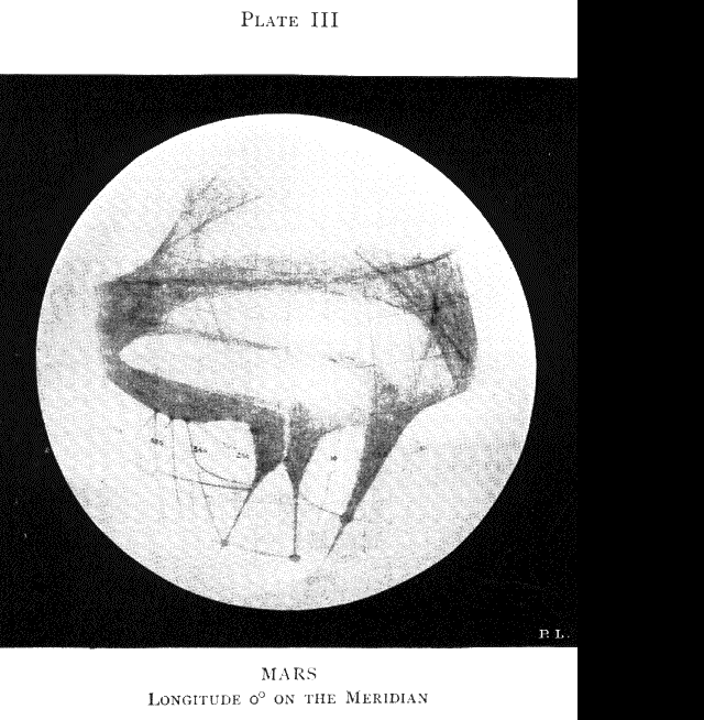 (Plate III.)
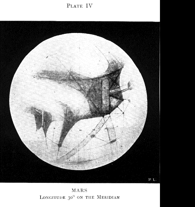
In Plate IV the markings have, under the rotation of the planet, all swung 30 degrees
to the east, thus bringing others into view from the west. The great swath
obliquely belting the disk is the canal called the Jamuna. It was, at the time
this picture represents it, apparently in process of doubling. Crossing it
obliquely is the Hydraotes. More conspicuous are two dark
swaths that make with
the Jamuna a nearly right-angled triangle. The lower one parallel to the edge
of the disk is the Dardanus; the other, ending at the south with the Jamuna in
the Aurorae Sinus, is the Ganges, one of the largest and most important of the
Martian canals. At the date of the drawing, it was distinctly double. The
doubling is very curiously prolonged by a narrow rectangle lying in the midst
of the dark regions to the south. Some idea of the size of these strangely
geometrical markings may be got by remembering that a degree on Mars represents
thirty-seven miles. Skirting the edge of the dark regions westward, we come to
a short canal, the Hebe, leading to the Fons Juventae, one of the tiniest
markings perceptible on the disk, from which, however, some six canals have
been found to radiate. Schiaparelli detected it in 1877, searched for it in
vain in 1879, but at subsequent oppositions found it again, happier than Ponce
de Leon in his futile quest after an earthly Fountain of Youth. Proceeding
still farther west, we reach the entrance to the Agathodaemon, at the point
where the edge of the dark regions abruptly trends southward. This canal brings
us to the Solis Lacus region, one of the most interesting parts of the planet.
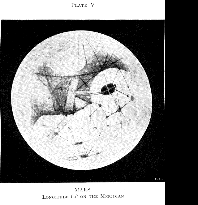
In Plate V. it has swung round into better view, where we will therefore
consider it.
The Solis Lacus is a great oval patch, measuring along its longest
diameter five hundred and forty miles. With small telescopic power or in poor
air it appears of uniform tint throughout, but under better visual conditions
dark spots appear in it, and bright causeways, which divide it into five
portions. Its longitudinal dividing line is prolonged into the Nectar, the
short canal connecting it with the dark regions to the east. The Nectar thus
appears double. Nor does the causeway stop here. It continues on between double
dark lines until it reaches the long rectangular area spoken of before as a
sort of continuation of the Ganges.
 In the next plate (Plate VI.), the Solis Lacus is central, the Lacus Phoenicis
somewhat to the right of the centre; and southwest of the Lacus Phoenicis is
the Beak of the Sirens, the eastern
end of the sea of the same name, which has
just come round the corner of the disk. The canal connecting it with the
Phoenix Lake is the Araxes; and at various angles to this, like spokes of a
wheel about the Phoenix Lake for hub, are many more canals, the one lying most
nearly due south being the Phasis. Connecting with this network of canals is a
similar network of streaks in the dark regions, making a set of triangles, from
which still other canals run up almost straight toward the south pole.
In the next plate (Plate VI.), the Solis Lacus is central, the Lacus Phoenicis
somewhat to the right of the centre; and southwest of the Lacus Phoenicis is
the Beak of the Sirens, the eastern
end of the sea of the same name, which has
just come round the corner of the disk. The canal connecting it with the
Phoenix Lake is the Araxes; and at various angles to this, like spokes of a
wheel about the Phoenix Lake for hub, are many more canals, the one lying most
nearly due south being the Phasis. Connecting with this network of canals is a
similar network of streaks in the dark regions, making a set of triangles, from
which still other canals run up almost straight toward the south pole.

The great
canal beaded with spots, which in the picture traverses nearly the centre of
the disk, is the Eumenides, and its continuation, the Orcus. Its farther end is
lost in the limb-light. At an angle to it, running nearly
northwest from the
Lacus Phoenicis, is the Pyriphlegethon. In this plate the Sea of the Sirens is
well on, its beak being almost on the central meridian. From its north coast
strike down a great many canals, all going as far as the Eumenides and some
continuing past it. The first one from the Beak of the Sirens is the Sirenius.
It crosses the Eumenides at the first of its large spots after leaving the
Phoenix Lake, the Lucus Arsine. To the next spot, known as the Nodus Gordii,
the Gorgon comes down from the centre of the coast-line, meeting the Gigas,
which itself debouches, at the west end of the sea, into what is called the
Sinus Titanum, or Gulf of the Titans.

In Plate VIII. the Sinus Titanum has come round into view.
Owing to its
conspicuousness at certain seasons, it is one of the most important features on
the planet to us, and seems to be to the planet itself, as some seven canals
radiate from it. These are the Gigas, previously described, and to the right,
in the order here enumerated, the Steropes, the Brontes, the Titan,--the one
straight down the disk,--the Arges, the Gyes, and the Tartarus; the last
travelling to the Trivium Charontis invisible in this plate. Of the separate
existence of the Arges and the Gyes I am not quite certain. These great canals
show like the sticks of a fan, with the Sinus itself for pivot.

On the next plate (Plate IX.) the Trivium Charontis itself has come into view
toward the lower right-hand part of the disk. Two nearly parallel canals, a
double Hades, join it to the Propontis, the Spot almost at the limb. The Titan
shows well near the centre of the disk. Were the centre ten degrees farther
east, the canal would appear more striking yet. For so straight is it, and so
nearly due north and south does it lie, that when it comes to the meridian it
seems that meridian itself. On this plate we have the western end of the
Eumenides-Orcus, at whose eastern end we began several plates back when we left
the Phoenix Lake. This will give some
idea of the immense length of the canal,
which is no less than three thousand four hundred and fifty miles long. Nearly
in the centre of the disk is the peninsula Atlantis, the most easterly of the
set of comet-tail peninsulas similar to those seen in Plate I., all connecting
the so-called continent with the islands to the south. These islands look not
unlike great vertebrae of the planet's backbone, in consequence of the canals
which cut them up so symmetrically. Atlantis shows well, between Mare Sirenum
and Mare Cimmerium, two areas suggestively alike in general shape and
directional trend. Both are seen to be crossed by canals which connect, at what
resemble nicks in the coast-line, with the canals in the bright regions.

In Plate X. the Mare Cimmerium is central. So, also, well down the disk, is the
Trivium Charontis. This is a very important junction, no less than nine canals
already being known to connect with it ,which, taken in the order, east, north,
west, and south, are the Orcus, the Erebus, the twin Hades, the Styx, the
Cambyses, the Cerberus, the Laestrygon, the Tartarus, and so back to the Orcus
again. In this picture the Laestrygon traverses nearly the centre of the disk.
To the right of the Trivium Charontis is the region called Elysium, one of the
brightest parts of the planet. It was here that Mr. Douglass made his
interesting
observation, last September, of a remarkable change of tint from
bright to sombre, and back to bright again, in the course of forty-eight hours;
suggesting perhaps the formation and dissipation of cloud, perhaps the
deposition and subsequent melting of hoar-frost over an area of some hundreds
of square miles.
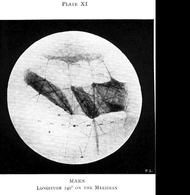
In the next picture (Plate XI.) Hesperia is central, dividing the Mare
Cimmerium on the left from the Mare Tyrrhenum on the right. The lower end of
the latter is called the Syrtis Minor, in contradistinction to the Syrtis
Major, which is just appearing round the western limb. From the bay, so to
speak, upon the left of Hesperia, two canals proceed down the disk in divergent
directions,--the most easterly one the Aethiops, the other the Achelous. From
the Syrtis Minor proceed two others, more or less similarly inclined,--the
Lethes and the Amenthes.
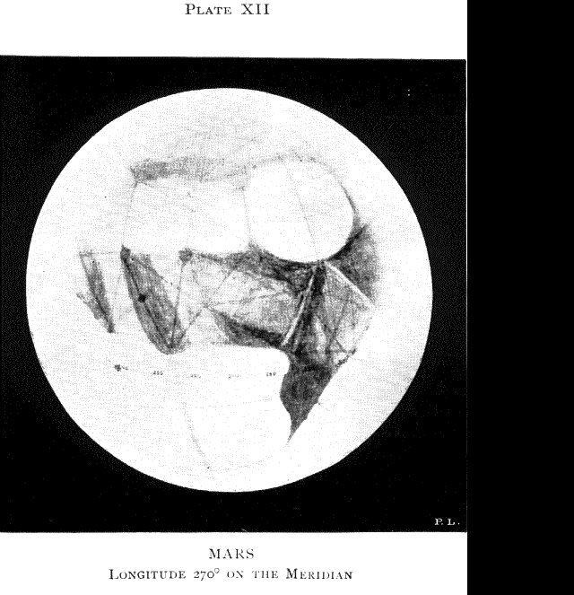
This region (Plate XII.) is interesting as having been the
scene of great changes at previous oppositions. There used to be a spot, the
Lake Moeris, in the midst of it, joined by the Nepenthes--the canal running
east and west about eight degrees north of the equator--to the Syrtis Major,
the great dark gulf somewhat to the west of the central meridian in the
picture. Latterly the Syrtis Major seems to have encroached upon Libya, and, at
the last opposition, only the faintest glimpses could be got of Lake Moeris,
which showed chiefly as a bay of the Syrtis Major itself. Here, as elsewhere, I
use aquatic names with terrestrial understanding.
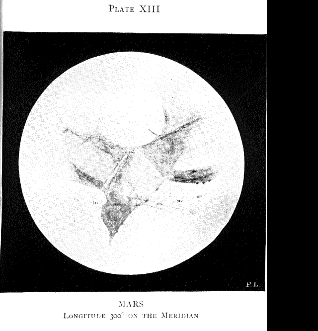
In Plate XIII. two features are striking, both not far from central on the
disk,--the lower, the Syrtis Major; the upper, Hellas. The Syrtis Major was
the first marking to be certainly recognized on Mars. It appears in
a drawing by Huyghens made on October 13, 1659,
the first drawing of Mars worthy the name
ever made by man, and reproduced on
page 20 from Flammarion's "La Planete
Mars." It is thus our oldest Martian acquaintance; Hellas is the surprisingly
round, bright area nearly on the meridian, and nearly half way from the equator
to the south pole. It is very strangely quartered by two canals, the Alpheus;
dividing it almost due north and south; and the Peneus, cutting it almost due
east and west. Between it and the Syrtis Major is the Mare Hadriaticum, a
blue-green area intersected by bright causeways and seamed by dark canals.
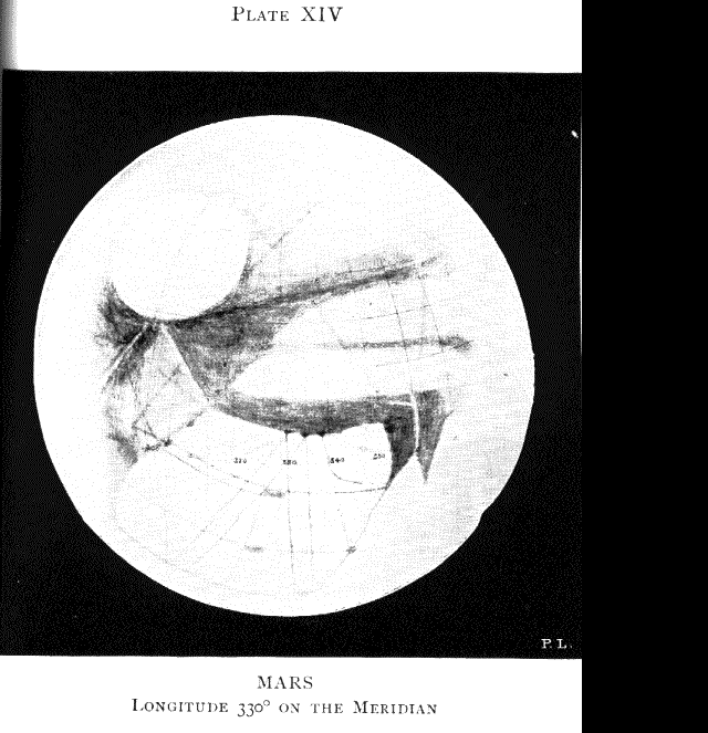
In the lower right-hand portion of the disk is an important region, bounded on
the east by the Syrtis Major, on the north by the Nilosyrtis and the
Protonilus, on the west by the Hiddekel, and on the south by the long dark area
to the north of Deucalionis Regio; its southeastern cape is the Hammonis Cornu;
its southwestern one, which appears in Plate XIV., is the Edom promontory. It
is a region prolific in double canals. The two most important of these are the
Phison and the Euphrates. Both start from the centre of the coast of the long
dark area between the Deucalionis Regio and the continent, and run, the Phison
northeast to the western end of the Nilosyrtis, in longitude 300 degrees, latitude 33 degrees
north; the Euphrates, nearly due north to the Lacus Ismenius, longitude 337 degrees,
latitude 37 degrees north, where it connects with the Hiddekel. Parallel to the
coast-line and
about 15 degrees to the north of it is, on the east, the Typhon, shown
double; on the west the Orontes, still single. Two other doubles shown in the
picture I saw also in this region, though I am not yet certain that they are
distinct from the Phison and the Euphrates, as the four were not seen together.
I have introduced them in the place where I saw them, because, first, no
optical effect explains any such shift; and, second, they run through and to
well-seen spots, which renders it more likely that they are distinct canals.
III. Seas
While it existed in any size, the polar sea was bordered on the north, all the
way round
and during all the time it was visible, by blue-green areas. These
blue-green areas were strewn with several more or less bright regions, while
below them came the great reddish-ochre stretches of the disk. Now, the
blue-green areas have generally been considered to be seas, just as the
reddish-ochre regions have been held to be land. That the latter are land there
is very little doubt; not only land, but nothing but land,--land very pure and
simple; that is, deserts. For they behave just as deserts should behave, that
is, by not behaving at all; remaining, except for certain phenomena to be
specified later, unchangeable.
Go to next chapter

WebGlimpse
Search:
The neighborhood of this page
The full archive
Go to line