 Copyright © Michael Richmond.
This work is licensed under a Creative Commons License.
Copyright © Michael Richmond.
This work is licensed under a Creative Commons License.
Right Ascension (or "RA") and Declination (or "Dec") are global coordinates: any particular star has the same RA and Dec for all observers on Earth, and that position remains the same, night after night. Altitude and Azimuth, on the other hand, are local coordinates: each observer sets up his own reference frame. Moreover, the altitude and azimuth of a given star will change over just a few minutes as the star appears to rise, move across the sky, and set.
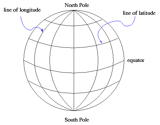
On Earth, one way to describe a location is with a coordinate
system which is fixed to the Earth's surface.
The system is oriented by the spin axis of the Earth,
and has special points at the North and South Poles.
We use lines of
latitude and longitude
to demarcate the surface.
It's obvious that latitude is measured away from the equator.
But where is the starting point for longitude?
There is no "obvious" choice.
After a lot of dickering,
European nations finally decided to use the
location of the Greenwich Observatory in England
as the starting point for longitude.
There are several ways to specify a location --
for example, that of the RIT Observatory.
One can use degrees:
Or degrees, minutes and seconds:
Or, in the case of longitude, one can measure in time zones.
The sun will set at the RIT Observatory about 5 hours and 11 minutes
later than it does at Greenwich,
so one could say
On can make a similar coordinate system which is "fixed
to the sky":
Once again, we use the Earth's rotation axis to orient the
coordinates.
There are two special places, the North and South Celestial
Poles.
As the Earth rotates (to the East),
the celestial sphere appears to rotate (to the West).
Stars appear to move in circles:
small ones near the celestial poles, and large ones close to the
celestial equator:
We again use two orthogonal coordinates to describe a
position:
Once again, there are several ways to express a location.
The star Sirius, for example, can be described as at
We can also express the Declination in Degrees:ArcMinutes:ArcSeconds,
just as we do for latitude;
and, as usual, there are 360 degrees around a full circle.
For Right Ascension, astronomers always use the convention of
Hours:Minutes:Seconds.
There are 24 hours of RA around a circle in the sky,
because it takes 24 hours for the Sun to move all the
way from sunrise to the next sunrise.
What's the difference between an "arcminute" and a "minute"?
These two angles specify uniquely the direction of
any object in the sky.
Some telescopes have
alt-az mounts
which swivel in these two perpendicular axes;
camera tripods and tank turrets are other examples
of alt-az devices.
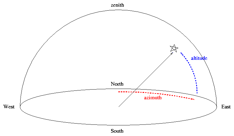
The altitude of an object is especially important from
an practical point of view:
any object which has an altitude less than zero is below
the horizon, and hence inaccessible.
Moreover, the altitude of an object is related to its
airmass,
a measure of how much air the light from that object
must traverse to reach the observer.
The larger the airmass, the more light is scattered or
absorbed by the atmosphere, and hence the fainter an
object will appear.
We'll deal with airmass at greater length a bit later.
However, note that two observers at different locations on Earth
will not agree on the (alt, az) position of an object.
Moreover, as the Earth rotates, an object in the sky appears to
move from East to West,
so its (alt, az) position changes from moment to moment.
It is possible to convert from (RA, Dec) to (alt, az), or vice versa.
One needs to know two factors:
In these modern times, it's usually easiest to use one
of the many fine planetarium programs on a computer to
do this work.
Right Ascension and Declination
latitude 43.0758 degrees North, longitude 77.6647 degrees West of Greenwich
latitude 43:04:33 North, longitude 77:39:53 West
latitude 43:04:33 North, longitude 05 hours 11 minutes West
The celestial coordinates
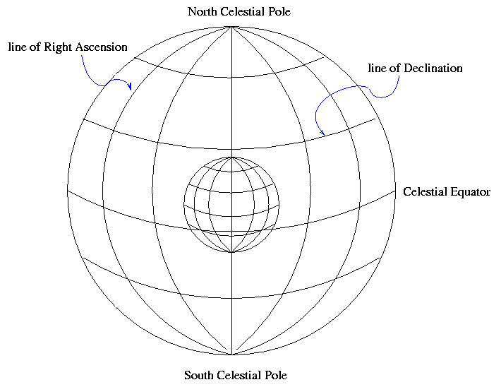

Image copyright
David Malin.
As with latitude, Declination is measured away from the celestial equator.
But there is again no obvious choice for the starting point of the
other set of coordinates.
Where should we start counting Right Ascension?
The rather arbitrary choice made by astronomers long ago was
to pick the point at which the Sun appears to cross the
celestial equator from South to North as it moves through the
sky during the course of a year.
We call that point the "vernal equinox".
Right Ascension 101.287 degrees, Declination -16.716 degrees
Right Ascension 06:45:09, Declination -16:42:58
meaning
Altitude and Azimuth
These two coordinates,
altitude (or "alt")
and
azimuth (or "az"),
are centered on the observer.
The calculations involve some spherical trigonometry.
One can find the details in any good book on celestial mathematics,
such as
Exercises
Copyright © Michael Richmond.
This work is licensed under a Creative Commons License.