 Copyright © Michael Richmond.
This work is licensed under a Creative Commons License.
 Copyright © Michael Richmond.
This work is licensed under a Creative Commons License.
 Magnetic
Pole
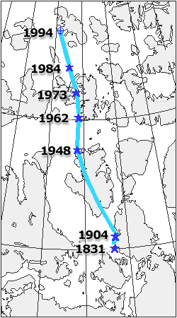
 When scientists plot the position of the magnetic north pole on a map, they plot its average position. Not only does the pole change its location over years and decades, but it also travels in a roughly elliptical path each day. This daily wandering can take the pole up to 80 km from where it is plotted!
Because the magnetic and geographic north poles are not in the same position, navigation by compass at high latitudes is misleading. For example, when travelling north on Ellesmere Island, your compass would actually indicate that you were heading south! At the magnetic pole, a free-hanging compass needle points directly downwards. This occurs because the magnetic field lines are heading straight down into the Earth's core.
This limitation on compasses made life difficult for navigators and explorers for centuries - until recently. In June 1993, the U.S. Air Force completed a worldwide radio-navigation system formed from a network of 24 satellites known as the Global Positioning System, or GPS. With a GPS receiver that costs a few hundred dollars you can now learn your location on the planet to within a few metres! This new technology depends upon a number of scientific and engineering advances, particularly the development of atomic clocks that are precise to within one billionth of a second! These clocks were created by physicists to aid their quest about the origins of the universe, with no conception that their technology would some day lead to a global system of navigation!
This page can be found at http://www.arctic.uoguelph.ca/cpe/environments/land/magpole/magpole.htm and is courtesy of the Canada's Polar Environments project at the University of Guelph.
 Copyright © Michael Richmond.
This work is licensed under a Creative Commons License.
 Copyright © Michael Richmond.
This work is licensed under a Creative Commons License.