 Copyright © Michael Richmond.
This work is licensed under a Creative Commons License.
Copyright © Michael Richmond.
This work is licensed under a Creative Commons License.
News from Hayabusa2 and its rovers!
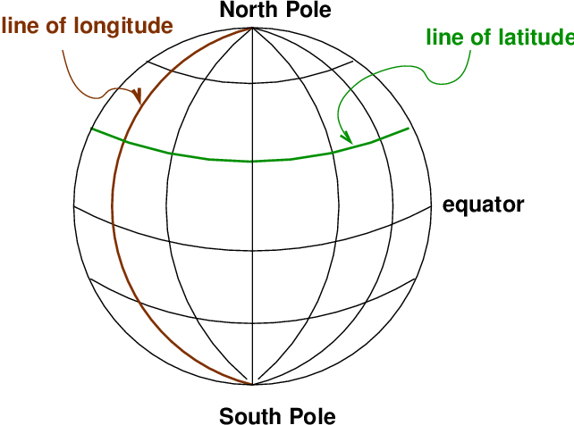
On Earth, one way to describe a location is with a coordinate
system which is fixed to the Earth's surface.
The system is oriented by the spin axis of the Earth,
and has special points at the North and South Poles.
We use lines of
latitude and longitude
to demarcate the surface.
It's obvious that latitude is measured away from the equator.
But where is the starting point for longitude?
There is no "obvious" choice.
After a lot of dickering,
European nations finally decided to use the
location of the Greenwich Observatory in England
as the starting point for longitude.
There are several ways to specify a location --
for example, that of the RIT Observatory.
One can use degrees:
Or degrees, minutes and seconds:
Or, in the case of longitude, one can measure in time zones.
The sun will set at the RIT Observatory about 5 hours and 11 minutes
later than it does at Greenwich,
so one could say
Latitude and longitude are global coordinates:
they are the same for all observers.
Everyone agrees, for example,
that Rochester is at
On can make a similar coordinate system which is "fixed
to the sky":
Once again, we use the Earth's rotation axis to orient the
coordinates.
There are two special places, the North and South Celestial
Poles.
As the Earth rotates (to the East),
the celestial sphere appears to rotate (to the West).
Stars appear to move in circles:
small ones near the celestial poles, and large ones close to the
celestial equator:
We again use two orthogonal coordinates to describe a
position:
Why do astronomers choose this coordinate system,
connected to the Earth?
Well, the main reason is that astronomers, too, are stuck
to the Earth. We all live on the surface of the Earth,
and we make our measurements from the surface.
Suppose I set up a telescope in a fixed position,
pointing in any particular direction,
and lock it into place.
As the Earth rotates, stars will appear to sweep through
my telescope's eyepiece from East to West.
But not all stars. My telescope will only see a few stars,
those with a particular Declination.
Night after night, those same stars will pass through
the eyepiece -- making it easy for me to measure their
positions.
A week later, if I shift my telescope to point slightly higher
above the horizon,
a new set of stars will move through my telescope --
stars with a slightly different Declination.
Once again, I can simply sit and watch them drift by
as time passes, and measure their positions carefully.
Only if we pick an Earth-centered coordinate system
will a fixed telescope observe stars within
a narrow range of some coordinate.
Because it simplifies the process of measuring stellar
positions,
an Earth-centered coordinate system is convenient for
astronomers.
Once again, there are several ways to express a location.
The star Sirius, for example, can be described as at
We can also express the Declination in Degrees:ArcMinutes:ArcSeconds,
just as we do for latitude;
and, as usual, there are 360 degrees around a full circle.
For Right Ascension, astronomers always use the convention of
Hours:Minutes:Seconds.
There are 24 hours of RA around a circle in the sky,
because it takes 24 hours for the Sun to move all the
way from sunrise to the next sunrise.
What's the difference between an "arcminute" and a "minute"?
Like latitude and longitude,
RA and Dec are global coordinates:
they are the same for all observers.
Everyone agrees, for example,
that Sirius is at
These two angles specify uniquely the direction of
any object in the sky.
Some telescopes have
alt-az mounts
which swivel in these two perpendicular axes;
camera tripods and tank turrets are other examples
of alt-az devices.
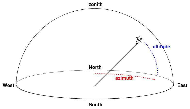
The altitude of an object is especially important from
an practical point of view:
any object which has an altitude less than zero is below
the horizon, and hence inaccessible.
Moreover, the altitude of an object is related to its
airmass,
a measure of how much air the light from that object
must traverse to reach the observer.
The larger the airmass, the more light is scattered or
absorbed by the atmosphere, and hence the fainter an
object will appear.
However, note that (alt, az) are local,
not global, coordinates:
two observers at different locations on Earth
will not agree on the (alt, az) position of an object.
Moreover, as the Earth rotates, an object in the sky appears to
move from East to West,
so even a single observer will
see its (alt, az) position change from moment to moment.
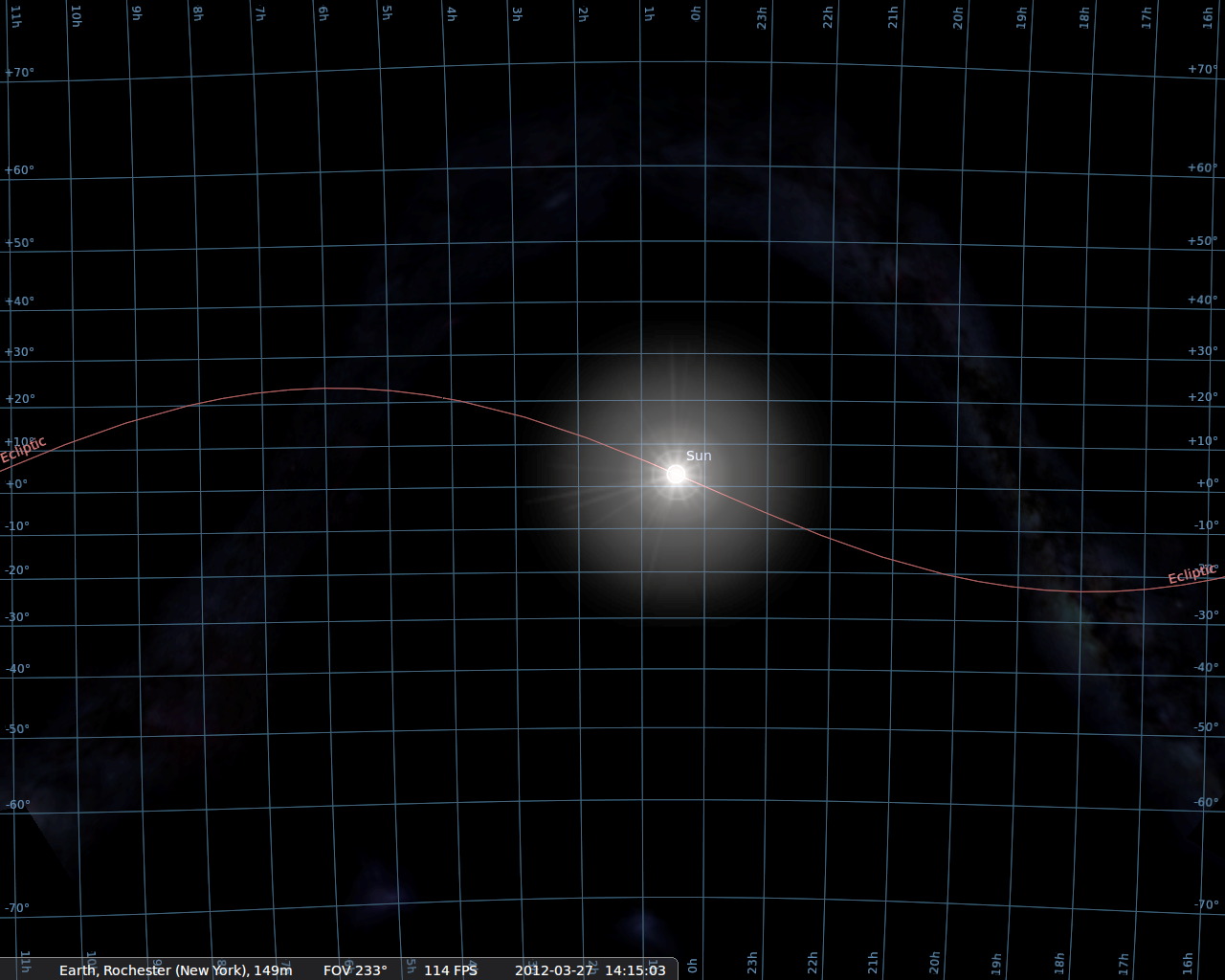
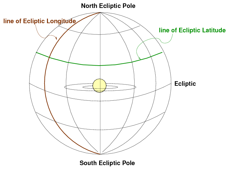
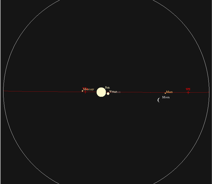
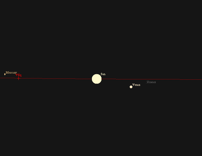
The ecliptic coordinate system is convenient when
dealing with objects in the solar system:
they are concentrated towards the ecliptic equator:
If you zoom in, you can see that the major planets
lie slightly above or below the ecliptic equator,
because their orbits around the Sun are inclined
slightly with respect to the Earth's.
Ecliptic coordinates can also be important when you
want to avoid the solar system.
Telescopes in space, such as the Hubble Space Telescope
or the Chandra X-ray Telescope,
cannot point close to the Sun
(or else they might suffer damage to their detectors).
For some purposes, astronomers want to make very,
very long exposures: days or even weeks long.
During such a long exposure, the Earth may move a
significant fraction of its entire orbit,
which can cause a target originally far from the Sun ....
... to move closer to the Sun, from the telescope's point
of view.
Therefore, astronomers sometimes choose their
very deep fields
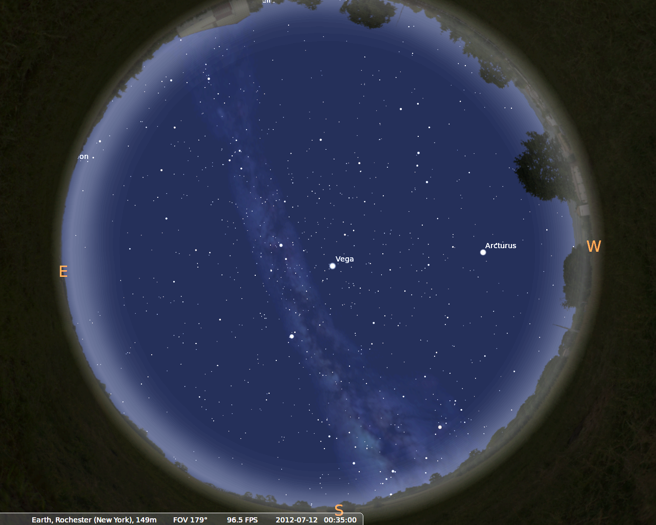
On a warm July evening in Rochester, the Milky Way
stretches overhead, with the galactic center
just above the southern horizon.
If you make a map of the sky in galactic coordinates,
the Milky Way runs right across the middle.
The section we see in the summer sky from Rochester is
in mostly the left half of this map.
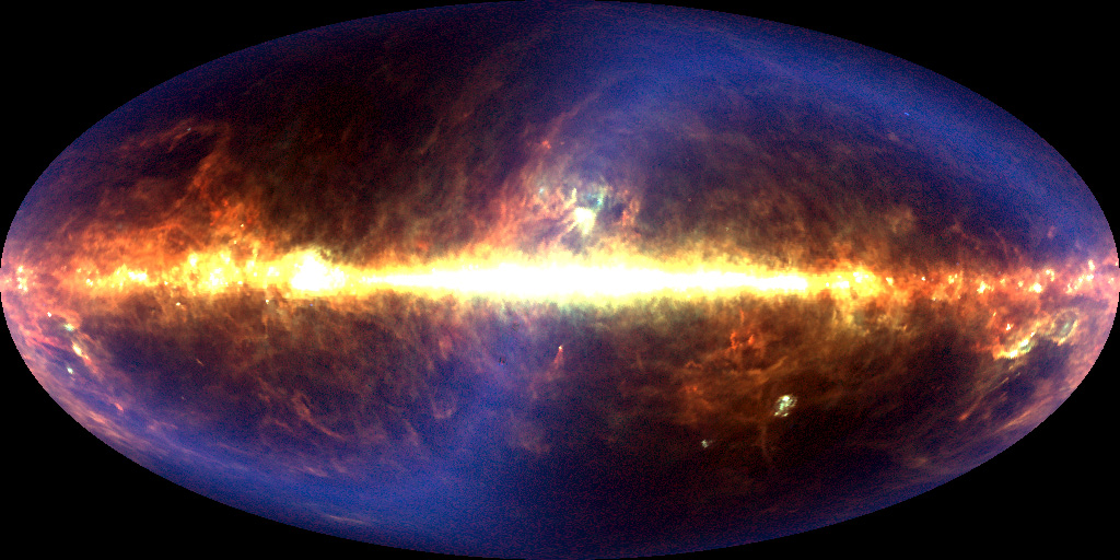
An infrared map of the sky in galactic coordinates
made by the COBE satellite is dominated by emission
from dust in the Milky Way,
but also shows a faint band of light
due to emission by dust particles in the
solar system.
Note that the plane of the solar system is tilted by almost
ninety degrees relative to the plane of the Milky Way.
Is this a good idea?
Perhaps you should see where it lies with respect to the
Milky Way, by converting its RA and Dec
to galactic coordinates.
There are several ways to do this --
I recommend one of these tools:
Last modified by MWR 3/13/2012
Right Ascension and Declination
  Q:  Why was Greenwich, England, chosen as the "center" of the
           longitude system?
latitude 43.0758 degrees North, longitude 77.6647 degrees West of Greenwich
latitude 43:04:33 North, longitude 77:39:53 West
latitude 43:04:33 North, longitude 05 hours 11 minutes West
    Rochester:  longitude 77 degrees West of Greenwich
                latitude  43 degrees North of equator
Earth-centered coordinates: Right Ascension and Declination
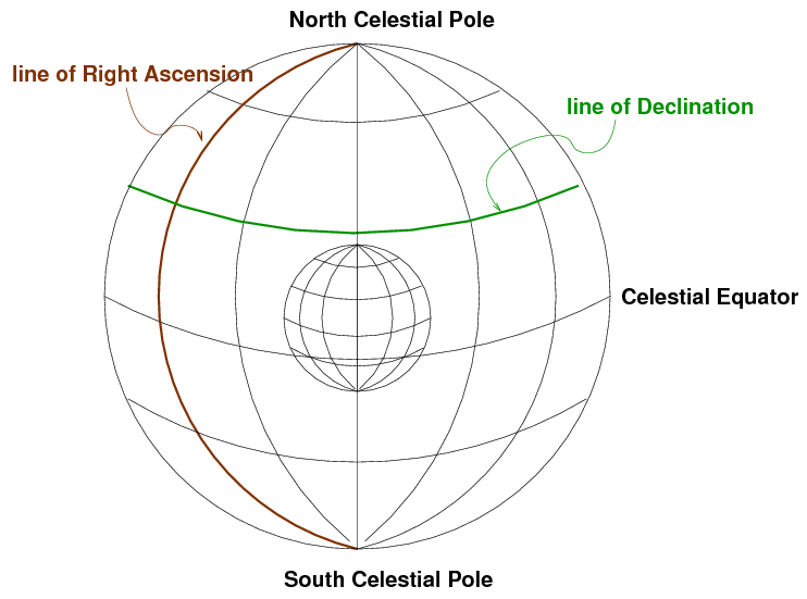
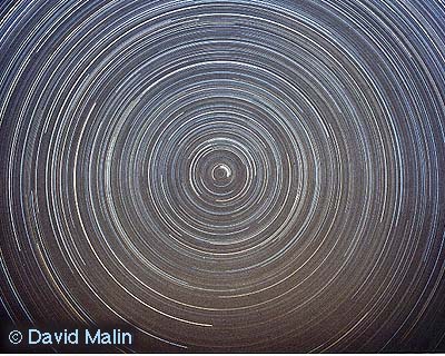
Image copyright
David Malin.
As with latitude, Declination is measured away from the celestial equator.
But there is again no obvious choice for the starting point of the
other set of coordinates.
Where should we start counting Right Ascension?
The rather arbitrary choice made by astronomers long ago was
to pick the point at which the Sun appears to cross the
celestial equator from South to North as it moves through the
sky during the course of a year.
We call that point the "vernal equinox".
Right Ascension 101.287 degrees, Declination -16.716 degrees
Right Ascension 06:45:09, Declination -16:42:58
meaning
    Sirius:     RA    101.287 degrees
                Dec   -16.716 degrees
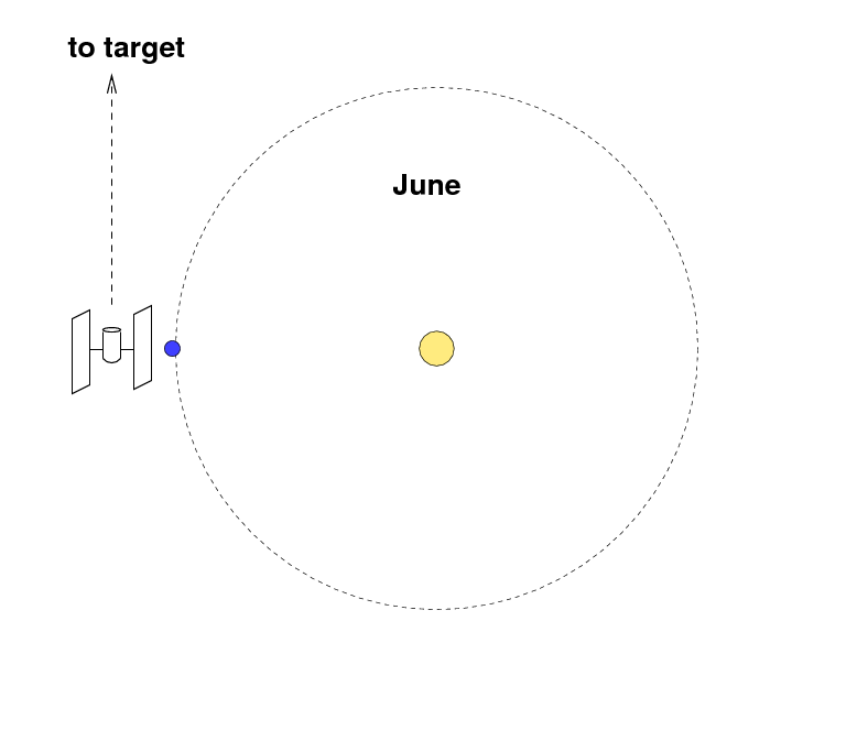
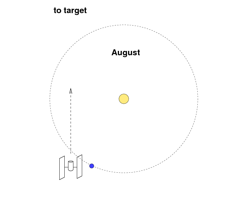
Altitude and Azimuth
These two coordinates,
altitude (or "alt")
and
azimuth (or "az"),
are centered on the observer.
They are the same coordinates that an
artillery officer would use to describe the
direction of a distant target --
so just imagine that your telescope is
a big gun.
Ecliptic (Solar System) coordinates
For objects within our solar system --
planets, asteroids, comets --
it often helps to use a coordinate system
centered on the Sun, with its equator running along
the plane of the planetary orbits.
We call this the ecliptic coordinate system.
  Q:  Is the ecliptic coordinate system a "global"
           or "local" system?  In other words, will all
           observers agree on the ecliptic coordinates
           of one particular object?
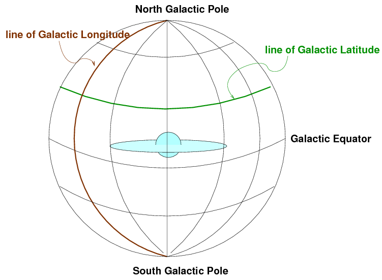
Galactic Coordinates
One more set of coordinates comes into play
if one studies the distribution of stars
within our Milky Way Galaxy,
or the distribution of other galaxies
in the far reaches of space.
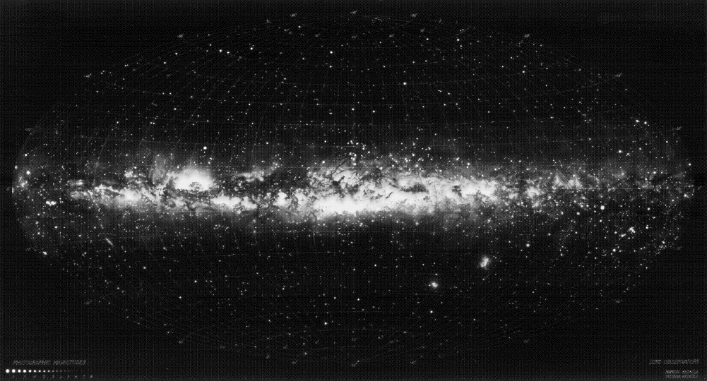
Map courtesy of the
Lund Observatory
  Q:  Is the galactic coordinate system a "global"
           or "local" system?  In other words, will all
           observers agree on the galactic coordinates
           of one particular object?
Converting between coordinates
Suppose that you know the coordinates of an object
in one system, but you need to know its
coordinates in a different system.
For example, someone tells you that you should
consider using HST to study a quasar located at
RA = 18:14:15 Dec = -29:03:39
Homework
Copyright © Michael Richmond.
This work is licensed under a Creative Commons License.